The Machame Route is Kilimanjaro’s most popular trail — and for good reason. Dramatic, varied, and visually stunning, it carries climbers through four distinct climate zones, past waterfalls, across alpine moorland, and up a spectacular volcanic landscape to Uhuru Peak. Nicknamed the “Whiskey Route” in contrast to the gentler Marangu “Coca-Cola Route”, Machame is the route of choice for adventurous trekkers who want scenery, challenge, and a strong summit success rate.
This guide gives you the complete 7-day Machame Route itinerary day by day, with camp elevations, daily distances, terrain descriptions, difficulty ratings, and practical tips from the Serac Adventure guide team in Moshi — who run the Machame Route more often than any other trail.
| Machame Route at a glance |
| Starting gate: Machame Gate (1,800m / 5,906ft) — south-western approach |
| Exit gate: Mweka Gate (1,640m / 5,380ft) — southern descent |
| Total distance: approximately 62km (38 miles) |
| Duration: 7 days (6-day option available but not recommended) |
| Highest point: Uhuru Peak, 5,895m (19,341ft) |
| Summit success rate (7-day): 82–87% with a reputable operator |
| Difficulty: challenging — physically demanding but no technical climbing |
| Serac Adventure price from: $1,700 per person (group rate) |
Why choose the Machame Route?
1. The most spectacular scenery on Kilimanjaro
The Machame Route passes through more dramatic visual variety than almost any other trail on the mountain. Day one plunges you into dense, mossy rainforest. By day two you are crossing the vast Shira Plateau with the summit towering ahead. Day five brings the Barranco Wall — one of the most thrilling sections of any African trek. The route circles Kibo’s southern flank, offering sustained views of both the summit and the plains far below.
2. Strong acclimatisation with the ‘climb high, sleep low’ strategy
The Machame Route includes a critical acclimatisation move on Day 3 — ascending toward Lava Tower (4,630m) before descending to Barranco Camp (3,976m). This “climb high, sleep low” pattern is the same strategy used on the Lemosho Route and is the primary reason Machame has a significantly higher summit success rate than the shorter Marangu Route.
3. All-camping experience — no huts
Unlike the Marangu Route, Machame is a camping-only trail. Sleeping in mountain tents at each camp gives the route an authentic, immersive feel — waking up to panoramic views at 4,000 metres, campfire evenings with your guide team, and a genuine sense of expedition. Serac Adventure provides spacious, high-quality mountain tents with sleeping mats at every camp.
4. Best route for combining with a post-climb safari
Because Machame is available in 7 days (vs 8 for Lemosho) and starts and ends near Moshi, it is an ideal choice for travellers with 14–16 day itineraries combining a Kilimanjaro climb with a 3–5 day Tanzania safari. See our Kilimanjaro and safari combo guide for full itinerary suggestions.
Machame Route 7-day itinerary — day by day
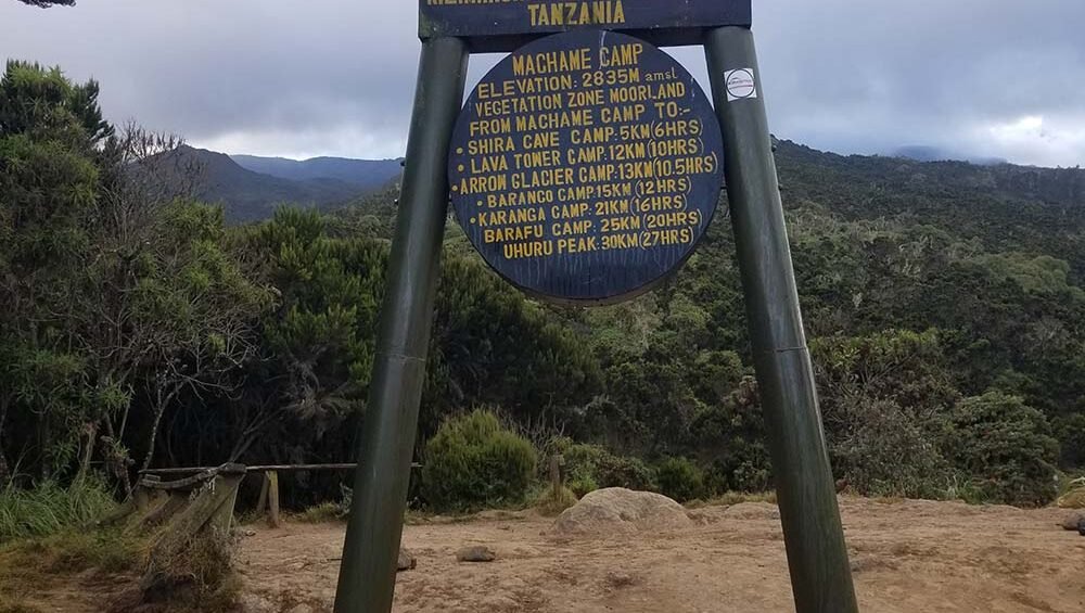
| Day 1 Rainforest | Start: Machame Gate (1,800m) End: Machame Camp (2,850m) Distance: ~11km Hiking time: 5–7 hours Habitat: Rainforest From Moshi, drive approximately 1 hour to Machame Gate for park registration and a meet-your-crew session. Begin hiking immediately through dense, green, cloud-draped montane rainforest. The trail is wide and well-worn, winding steadily uphill through moss-covered trees. Colobus monkeys are frequently spotted in the canopy. A long first day — arrive at Machame Camp in late afternoon, set at the rainforest edge with early views of the Shira Plateau above. |
| Day 2 Moorland | Start: Machame Camp (2,850m) End: Shira Camp (3,840m) Distance: ~5km Hiking time: 4–6 hours Habitat: Heath and moorland Leave the rainforest behind and enter the open heath and moorland zone. The trail steepens considerably as you climb onto the Shira Plateau — a vast, flat-topped ancient volcanic caldera. Giant heather shrubs, lobelia plants, and the first sweeping views of Kibo ahead. Shira Camp sits on the plateau edge with Mount Meru visible to the east on clear days. |
| Day 3 Acclimatisation | Start: Shira Camp (3,840m) End: Barranco Camp (3,950m) via Lava Tower (4,630m) Distance: ~14km Hiking time: 6–8 hours Habitat: Alpine desert The most important day on the route. Trek east across the plateau toward Lava Tower — a dramatic 300-metre volcanic plug at 4,630m. This is the highest point you reach before summit day, and the body’s response to this altitude is critical for acclimatisation. After time at Lava Tower, descend to Barranco Camp for the night. Despite ending just 110m higher than you started, your body has been stimulated by the high-altitude exposure and begins producing more red blood cells. |
| Day 4 Barranco Wall | Start: Barranco Camp (3,950m) End: Karanga Camp (4,035m) Distance: ~5km Hiking time: 4–5 hours Habitat: Alpine desert Wake to the towering Barranco Wall immediately above camp — a 257-metre rock face that looks dramatic but is a scramble, not a technical climb. Your guides assist at key points and the route is clearly marked. After the wall, traverse the southern circuit through a series of ridges and valleys with spectacular views. The shorter hiking distance is welcome after the demanding Day 3. |
| Day 5 High camp | Start: Karanga Camp (4,035m) End: Barafu Camp (4,673m) Distance: ~5km Hiking time: 3–5 hours Habitat: Alpine desert / lunar landscape A morning of steady hiking across bare, rocky terrain to Barafu Camp — the final camp before the summit. The landscape here is stark and lunar, with little vegetation above 4,500m. Arrive by midday, eat a hot lunch, and rest for the remainder of the afternoon. Your guide will brief you on summit night — the most demanding night of the climb. Try to sleep from mid-afternoon; midnight comes very quickly. |
| Day 6 Summit night | Start: Barafu Camp (4,673m) End: Uhuru Peak (5,895m) then Mweka Camp (3,100m) Distance: ~14km total Hiking time: 5–7 hrs ascent + 4–5 hrs descent Habitat: Arctic summit zone Depart at midnight (or 1am) by headlamp in total darkness. The trail switchbacks steeply up loose scree — the hardest, coldest, most psychological hours of the entire journey. The pace is extremely slow: pole pole. Reach Stella Point on the crater rim (5,756m) at dawn — frequently rewarded with one of the most spectacular sunrises imaginable. Continue 45 minutes along the crater rim to Uhuru Peak. After the summit, descend all the way to Mweka Camp — a brutal 1,795m descent on tired legs. |
| Day 7 Final descent | Start: Mweka Camp (3,100m) End: Mweka Gate (1,640m) then Moshi Distance: ~10km Hiking time: 3–4 hours Habitat: Rainforest A final descent through the rainforest to Mweka Gate. Legs will be aching from yesterday’s long day but the forest is green, the air is rich, and the sense of achievement is enormous. Summit certificates are presented at the gate. Transfer back to Moshi for a celebration meal and a very well-deserved rest. |
Elevation profile summary
| Day | Start camp | End camp | End elevation | Key elevation |
| Day 1 | Machame Gate | Machame Camp | 2,850m | Gate at 1,800m |
| Day 2 | Machame Camp | Shira Camp | 3,840m | +990m |
| Day 3 | Shira Camp | Barranco Camp (via Lava Tower) | 3,950m | High point 4,630m |
| Day 4 | Barranco Camp | Karanga Camp | 4,035m | Barranco Wall 4,207m |
| Day 5 | Karanga Camp | Barafu Camp | 4,673m | +638m |
| Day 6 | Barafu Camp | Mweka Camp (via Uhuru Peak) | 3,100m | Summit 5,895m |
| Day 7 | Mweka Camp | Mweka Gate | 1,640m | -1,460m |
The Barranco Wall — what to expect
The Barranco Wall is the most talked-about feature of the Machame Route and deserves its own section. This 257-metre (843-foot) rock face above Barranco Camp is climbed on Day 4 morning and looks, in photographs, like a sheer vertical cliff.
The reality is less terrifying. The Barranco Wall is a hands-and-feet scramble — there are always three points of contact and a clearly defined path. There are no exposed sections where a fall would be dangerous. Your guides assist at all key moves. Most climbers describe it as exhilarating rather than frightening.
- It is NOT a technical climb — no ropes, harnesses, or special equipment needed
- It IS a scramble — you will use both hands and feet throughout
- The path is busy in peak season — it can feel like a queue at certain bottlenecks
- Trekking poles should be collapsed and stowed in your daypack before the wall
- Total time to climb the wall: approximately 45–60 minutes
- Often called the ‘Breakfast Wall’ because it is climbed immediately after the morning meal
Difficulty and fitness requirements
The Machame Route is rated as challenging — one step above Lemosho in physical demand due to the steeper initial ascent and the more demanding summit night approach. It is appropriate for fit and motivated trekkers who have experience with long hiking days (5–8 hours) and do not have any relevant medical contraindications.
- Previous hiking experience on multi-day trails is beneficial but not required
- High-altitude experience is not required but altitude awareness is important
- Summit night is the hardest challenge: 5–7 hours of steep climbing in darkness and cold
- Physical fitness training should begin 8–12 weeks before departure
- The 6-day Machame option is not recommended — the acclimatisation is significantly inferior
What’s included in Serac Adventure’s Machame package
- All KINAPA national park fees and camping fees
- Experienced KINAPA-certified lead guide and assistant guide(s)
- Dedicated porter team — minimum 1.5 porters per climber
- Mountain cook with three hot meals per day plus snacks and hot drinks
- All camping equipment: sleeping tents, dining tent, toilet tent, sleeping mats
- Safety equipment: pulse oximeters, supplemental oxygen, first aid kit
- Airport and hotel transfers from Moshi or Arusha
- Pre-climb gear check and briefing at our Moshi office
- Summit certificate on descent from Mweka Gate
Not included: personal trekking gear, international flights, travel insurance, crew tips ($250–$350 recommended).
Frequently asked questions: Machame Route
Is the Machame Route harder than Lemosho?
Marginally, yes. The Machame Route is one day shorter with the same total elevation gain, meaning the average daily ascent is slightly steeper. The 8-day Lemosho also has a superior acclimatisation profile. That said, both routes suit fit, motivated trekkers and the difference in difficulty is not dramatic.
Why is the Machame Route called the Whiskey Route?
The nickname ‘Whiskey Route’ is a playful contrast to the Marangu Route’s ‘Coca-Cola Route’ nickname. It implies that Machame is the stronger, more intense option — requiring more physical effort and determination. The names are informal and in no way reflect the quality of experience on either route.
Should I do the 6-day or 7-day Machame?
Always choose 7 days. The 6-day Machame combines Days 4 and 5 into one very long day, reducing acclimatisation time and significantly increasing AMS risk and the chance of a failed summit. The extra day costs a modest amount more but delivers a meaningfully higher chance of reaching Uhuru Peak safely.
Can I combine the Machame Route with a Tanzania safari?
Absolutely — this is one of our most popular combinations. After your 7-day Machame climb and 1 night recovery in Moshi, you are well-positioned for a 3–5 day northern circuit safari covering the Serengeti, Ngorongoro Crater, and Tarangire before flying home. See our Kilimanjaro and safari combo guide for sample itineraries.
When is the best time to do the Machame Route?
The Machame Route is best during Tanzania’s two dry seasons: January–early March and June–October. August and September are peak season with the best weather but the most crowded camps. January and February are excellent with fewer climbers and slightly warmer summit temperatures. See our best time to climb Kilimanjaro guide for details.
| Book the Machame Route with Serac Adventure 7-day Machame packages from $1,700 per person — KINAPA-licensed, local Moshi operator. All park fees, guides, porters, meals, camping equipment, and transfers included. Contact us: +255 785 790 460 (WhatsApp) | info@seracadventure.com Based in Moshi, Tanzania — at the foot of the mountain. |